tva logoTennessee Valley Authority

Chatuge Reservoir

Photo of Chatuge reservoir with mountains in background

Chatuge Reservoir, located on the Hiwassee River in western North Carolina, is 13 miles long and extends southeast from the dam into north Georgia. The reservoir is named after a nearby Cherokee settlement.

General Information

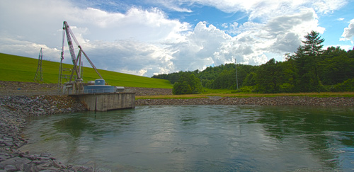
Sport fishing is popular at Chatuge, both in the reservoir and in the Hiwassee River below the dam. A concrete weir has been installed below the dam to provide a steady flow of water in the riverbed and to increase oxygen levels for fish and other aquatic animals. Wade fishing for trout is popular here since fish are attracted to the weir, where food is abundant.

Chatuge is operated for many purposes, including flood damage reduction, power generation, and augmentation of water flows for navigation downstream.

More information on Chatuge Reservoir

Operating guide

Daily reservoir operation information

Sportfish survey results

Sportfish ratings

Ecological health ratings

Tailwater improvements

Recreation facilities


Chatuge: Facts & Figures

Construction of Chatuge Dam began in 1941 and was completed in 1942.

The dam is 150 feet high and stretches 3,336 feet across the Hiwassee River.

Chatuge was originally built to store water to help reduce flood damage downstream. A single hydropower generating unit was added in 1954 with a net dependable capacity of 13 megawatts. Net dependable capacity is the amount of power a hydroelectric dam can produce on an average day, minus the electricity used by the dam itself.

In a year with normal rainfall, the water level in Chatuge Reservoir varies about 10 feet from summer to winter to provide seasonal flood storage.

Chatuge has a flood-storage capacity of 62,600 acre-feet.

           
Content for id "future1" Goes Here
Content for id "future2" Goes Here
Content for id "future3" Goes Here