

Fontana Reservoir
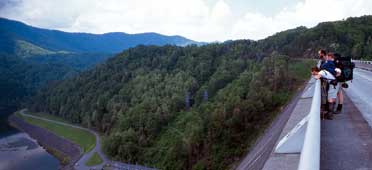
Hikers on the Appalachian Trail stop to admire the view from atop Fontana Dam. The highest dam east of the Rocky Mountains, Fontana is on the Little Tennessee River in western North Carolina.
Fontana Reservoir occupies a site of particular splendor deep in the Great Smoky Mountains. Fishing, boating, and swimming are all popular at Fontana, but it is perhaps most appreciated by wilderness hikers and campers.
The Appalachian Trail, which extends over 2,000 miles from Georgia to Maine, crosses Fontana Dam. The hot showers available at the trail shelter, maintained by TVA, have led grateful hikers to dub it the Fontana Hilton. The Great Smoky Mountains National Park borders the reservoir to the north.
Fontana was built during World War II to provide electric power for the war effort. A new town, housing some 5,000 people who worked around the clock in three shifts, sprang up in the forest, and the project broke construction records. What was once the construction village is now a resort offering recreational activities such as boating, horseback riding, and crafts making.
Visitor Center
The Fontana Dam Visitor Center is located off N.C. Highway 28 near the Tennessee/North Carolina state line. It is open from 9 a.m. to 6 p.m. daily from May through October except for major holidays and in times of severe weather. Newly refurbished and staffed by TVA retirees, the visitor center has updated maps, videos, and displays about TVA and the construction of the dam.
More information on Fontana Reservoir
Daily reservoir operation information